#CovidMobility Measures and Major Walking and Cycling Projects -July 2021
Part A: COVID Mobility Measures Update
- Introduction
As the Government restrictions and advice has changed over the last number of months the Covid Mobility Team have been able to continue work on those interventions that have been designated critical infrastructure.
1.1 Pedestrian Volumes
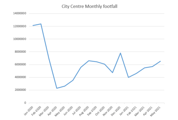
Dublin City Council (DCC) footfall counters in the city center show footfall in the core city area. Footfall has been climbing steadily and is now 80% higher than it was in early January with a notable increase since outdoor dining resumed.

Examining the footfall since the start of 2020 we can see that currently footfall is similar to last summer (2020).
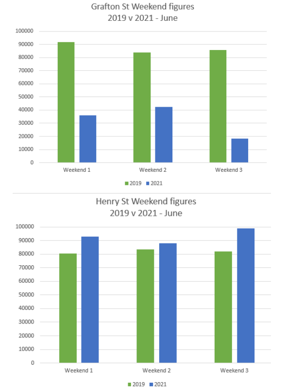
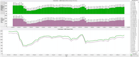
The bar charts below show the Northside of the city is still showing significantly higher footfall than the Southside with footfall on the Northside now exceeding pre-Covid levels.
1.2 Cycling Volumes
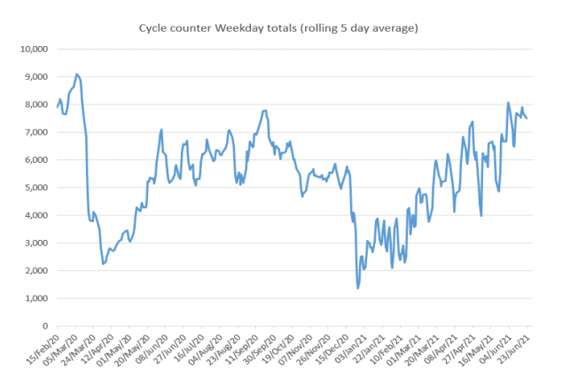
Cycling numbers continue to increase and are at the highest levels since February 2020, almost back to pre-Covid levels.
1.3 Bus Passenger Numbers
There has been a noticeable increase in bus passenger volumes since the Easter mid-term break and the easing of restrictions. Passenger numbers currently stand at approximately 50% of pre-Covid volumes.

1.4 General Traffic Volumes
The trend shows a steady increase on traffic volumes crossing the cordon since the start of the year. Traffic volumes are currently approximately 82% of pre-Covid levels.
2. Pedestrian Crossing
2.1 Pedestrian Crossings
Design work has begun on a number of pedestrian crossings across the city, which are due to be installed later in the year.
2.2 Mountjoy Pedestrian Crossing (North West corner):
We are still waiting on the delivery of cable (which has been severely delayed due to Brexit restrictions) to allow us complete Phase 1 of this junction, which provides new pedestrian crossings on two arms of this junction.
2.3 Dolphins Barn / SCR junction:
It is intended to install a small traffic calming measure at the junction of Dolphins Barn/South Circular Road. The design is currently being finalised.
3. Protected Cycle Facilities and Contra-Flow Cycle Facilities
3.1 Griffith Avenue Cycle Route
We are currently completing the installation of bollards to protect the cycle lanes between the Swords Road and the entrance to the Charlemont Estate. We do not intend proceeding any further east from this point until the drainage works along Griffith Avenue from the new Cairns site to the Malahide Road are completed later in the summer. In the meantime, we are in the process of awarding the contract to modify the junctions of Griffith Avenue / Ballymun Road / St Mobhi Road. Works should start next month to provide this link between Griffith Avenue and the Griffith Avenue Extension.
3.2 Collins Avenue Cycle Route
Drawings for the proposals between Larkhill Road and Ballymun Road will be published on the Consultation Hub later this week. It is also intended to go for tender for a section of extruded kerb in this location.
3.3 On-Street Cycle Parking
The installation of Batch 17 has commenced.
4. Walking & Cycling Network Improvement
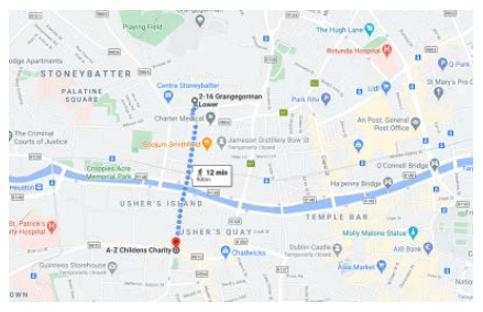
4.1 Grangegorman to Thomas Street Walking and Cycling route:
As presented to members of the Central and South Central Area Committee meetings, the scheme’s main objective is to provide an improved pedestrian route and segregated cycle track linking the communities of Stoneybatter, Grangegorman and surrounds to the Liberties and vica versa while also connecting to the Thomas street cycle route via Queen Street and Bridgefoot Street. It will also connect to the interim Liffey cycle route.
The scheme will provide a safe environment for pedestrians with additional toucan crossings along the route, while for cyclists it will provide a route completely segregated from vehicular traffic. The project may also provide the opportunity to improve the public realm at a variety of locations and will tie in with the DCC Parks development on Bridgefoot Street.
The project will integrate with the proposed Bus Connects Corridor 5, Blanchardstown to City Centre. Funding has recently been secured from the NTA and the detailed design is underway. The exact timeline for implementation will become more apparent as the detailed design progresses, however, at this stage we anticipate construction starting in Q1 of 2022.

5. City Recovery – Business Support
The Covid Mobility Team are providing considerable resources to assist the City Recovery Programme through the re-allocation of road space to facilitate on-street dining across the City. A number of measures including footpath buildouts, “Zebra” interventions and traffic management changes have been completed. All applications for outdoor dining are assessed by the Covid Mobility Team to determine the most suitable intervention.
5.1 Footpath Buildouts
Footpath buildouts have been installed at 18 locations to-date, providing 1,814m2 of additional space for outdoor dining. The majority of the build-outs on Capel Street have now been installed. One remaining buildout on the eastern side of the street immediately south of Middle Abbey Street will be installed as soon as new materials are delivered.

5.2 Zebra Interventions
Zebra interventions re-allocate a small number of car parking for outdoor dining and consist of black and white stripped (Zebra) planters providing separation from the carriageway while keeping the footpath clear for pedestrians.

5.3 New Market Square
Design for an outdoor market space in Newmarket Square in Dublin 8 is currently being finalized by the South Central Area Office. The Covid Mobility Team is working with the SEA Office on new traffic arrangements.
6. Pedestrian Areas
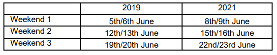
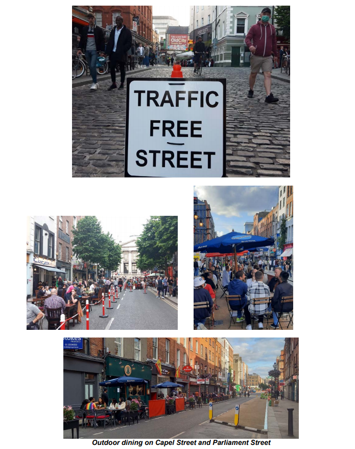
6.1 Capel Street & Parliament Street
For six weekends, which started on 11 June, Capel Street and Parliament Street are Traffic free streets every Friday, Saturday and Sunday evening from 6.30pm to 11.30pm. This is to provide additional space for pedestrians and for outdoor dining.
6.2 Grafton Street Area
Following the strong public support and the successful pedestrianisation trials last summer, the following streets, were made traffic free or partially traffic free on 24 May:
– South Anne Street
– Dame Court
– South William Street (Exchequer St to Brown Thomas carpark)
– Drury Street
7. School Mobility Programme
7.1 School Zones
The application list for a School Zone currently stands at 126 Schools. The COVID Mobility Technical Team continue to assess all submissions for suitability and schools are contacted with timelines if it is deemed to be an appropriate intervention at the particular location. To date a total of 47 School Zones have been installed across the city. The breakdown of the School Zones completed per administrative area of Dublin City are, 14 in the South Central Area, 10 in the South East Area, 11 in the Central Area, 7 for the North West Area and 5 in the North Central Area.
There are a total of 33 schools, at design stage, subject to final consultation with school Principals and the NTA. There has been 27 site visits to potential new School Zone locations conducted by the School Outreach Officers since 7 June.

The following School Zones will be installed in the next 6-8 weeks:
• St Catherine’s Ratoath Rd Cabra West, Dublin 7.
• St. Dominic’s College, Ratoath Road, Cabra West, Dublin 7.
• Holy Child National Boys National School, Larkhill Road, Whitehall, Dublin 9.
• Holy Child National Girls National School, Larkhill Road, Whitehall, Dublin 9.
• Georges Hill, PPS, Halston Street, Dublin 7.
• Rutland Street National School, Lower Gloucester Place, Dublin 1.
• Scoil Assaim, All Saints Drive, Clontarf East, Dublin 5.
• Scoil Naí-Íde, All Saints Drive, Clontarf East, Dublin 5.
• Scoil Aine, All Saints Park, Clontarf East, Dublin 5.
• Springdale National School, Lough Derg, Edenmore, Dublin 5.
• Our Lady Of The Wayside, Bluebell, Dublin 12
As part of our monitoring process, the Outreach Officers are also conducting site visits at implemented School Zones to observe the traffic behaviour at either drop off or collect times around the school gate. These site visits will inform the development of School Zone Action Plans for September. Feedback received at these site visits from adults accompanying children to School has been predominantly positive:
“It is aesthetically pleasing and a good indication for those who do not know the school is here and to slow down.”
“Kids could not cross on the bike, and parents used to park on the path, now they don’t park.”
“Now there is awareness that the school is there.”
7.2 Safe Routes to School
Twenty-eight schools in the DCC area have been successful in round 1 of the Safer Routes to School programme. The aim of this programme is to:
- Improve safety at the school gate by providing “front of school” treatments to alleviate congestion and improve access;
- Improve access routes to school by improving walking and cycling infrastructure;
- Increase the number of students who cycle to school by expanding the amount of cycle parking.
The applications were assessed by Green-Schools and the shortlist compiled based on criteria agreed with the Department of Transport and the National Transport Authority as follows:
- Mix of school type (primary, post-primary, other)
- Mix of location (Urban(village, town, city) suburban, rural)
- Socio- economic mix (non-DEIS, DEIS schools)
- Schools commitment to sustainable travel
- Cluster of schools
Many of the successful school have already received a School Zone or are on the list to be assessed for a School Zone. Two of the successful applications are Secondary School which were ineligible to apply for a School Zone. A number of successful applicants are in 50km/h zones. DCC will work with the NTA and Green-Schools to determine most appropriate intervention at each specific location.
7.3 Cycle & Scooter Parking for Schools & Sports Clubs
The final batch of cycle and scooter parking is due to be delivered to schools and sports clubs in the next month.

8. Communications
8.1 Website
The COVID Mobility webpage, is being updated regularly to keep the general public informed of COVID mobility interventions. As previously advised we will be making more extensive use of the Consultation Hub to provide information on proposed measures.
8.2 DCC Consultation Hub/Citizen Space
Details of schemes on the Consultation Hub at present include:
Griffith Avenue Protected Cycle Track
Members are alerted on a regular basis to any new proposals, which are available to view on the Consultation Hub. The aim is to have a more dynamic process for ensuring that support for projects, suggestions on how to improve them and concerns and issues, which may need to be addressed, can be handled. Any feedback on this approach is welcome.
8.3 Dedicated COVID-19 Mobility Measure Request Form
We have received 323 new requests for COVID Mobility Measures in the past month. This brings the total number of COVID Mobility requests to 5,987. A breakdown of these requests is below:

8.4 COVID Mobility E-Mail
The dedicated e-mail address continues as the primary channel to contact the COVID Mobility Team.
It is attracting huge volumes of queries and feedback. The intention is that the e-mail is for general queries and the COVID Mobility Request Form should be used for specific requests at specific locations.
8.5 Councillor Updates
Updates on COVID-19 mobility measures will in future be issued to Elected Members via the combined monthly report on a monthly basis. Updates via e-mail are also being issued to stakeholders via the Transportation SPC and to the NTA for distribution to disabled persons user groups.
8.6 Active Travel Promotion
We are continuing to utilise Dublin City Council Social Media Channels:
- to highlight COVID-19 mobility measures that have been implemented;
- to encourage the public to walk or cycle, where possible
- to encourage social distancing as people move around the city and;
- to encourage more respect for vulnerable road users.
Part B: Walking & Cycling Major Infrastructure Projects
- 5-Year Walking and Cycling Infrastructure Delivery
Over the next five years, Dublin City Council will undertake the planning and implementation of up to 140km of cycling and walking infrastructure. This is made up of 55km from 27 existing projects and 85km from 31 new corridors. The full list was circulated in Report No 67/2021 issued in February 2021. Over the next six months, as Project Teams are set up, these projects will be assessed further in order to develop a comprehensive programme for delivery. This assessment of the corridors has now been commenced, starting with;
Finglas to Killester Corridor:
The overall corridor is approximately 7.3km long. The assessment is seeking to identify projects along this corridor that can be delivered over the course of five years. It is anticipated that a list of interventions along this corridor will be presented to the North West and North Central Area Committees in autumn 2021.
Santry Greenway:
The project will include a river restoration and biodiversity. It is
being led by the Water Framework Directive Office.
Kilmainham to Thomas Street:
The assessment of the corridor has also started. It is anticipated that a list of Interventions along this corridor will be presented to the South Central Area Committee in autumn 2021.
In addition, a number of infrastructure projects that had been paused will be resumed. The following projects will resume is June 2021;
• Dodder Greenway: The NTA Cycling Design Office has been reviewing the emerged preferred option. The meetings for the Dodder Greenway Steering Group resumed on 15th June 2021.
• Grand Canal Greenway (Blackhorse to Portobello): A project team has been set up and work has commenced with a review of current proposals in the context of new projects that have come on stream, such as Busconnects.
2. Schemes with Statutory Planning Approval
There are no new schemes undergoing the statutory planning process. This is unchanged from last month. There are four projects with statutory planning consent. These are:
- Royal Canal Greenway
- Dodder Greenway
- Clontarf to City Centre
- The Point Junction Improvement Scheme
2.1 Royal Canal Greenway
The Royal Canal Greenway is being delivered in four phases.
Phase 1: Implemented.
Phase 2: The site is looking great and this summer it will enhance opportunities for communities to walk and cycle as well as a visual amenity. Landscaping is now substantially complete. There will be additional work required in August-September to plant all the spring bulbs. These will provide even more attraction. This is as reported last month.
Phase 3: Tenders leading to the appointment of a works contractor were received at the end of May 2021. It is anticipated that a Contractor appointment will be made in Q3 2021. This is as reported last month.
Phase 4: The designs for the amending Part 8 for the section between the 6th Lock and Coke Oven Cottages is complete. A presentation of the Part 8 process will be made to the Central Area Committee in July 2021. It is schedule to have a works contractor on site in Q4 The overall schedule remains unchanged from the last report.
2.2 Dodder Greenway (Herbert Park to Donnybrook)
A preferred tender has been selected. It is anticipated that works will start on site in September 2021.
2.3 Clontarf to City Centre
Tenders leading to the appointment of a works contractor were received in May 2021. Information on the project is now accessible on the DCC webpages. The address is http://www.dublincity.ie/c2cc. The following information is now available;
• Project Overview and Progress Update
• Drawings and Visualisations
• Bus Stop Design
• Temporary Traffic Management
During the month, the Project Team has been developing bus stop designs following the engagement with disability groups and organisations and preparing information leaflet, based on the feedback received from members.
2.4 The Point Junction Improvement Scheme
The Point junction improvement scheme has now been incorporated into the new Pedestrian and cycling bridge beside the Tom Clarke Bridge and will allow the design team to integrate the changes required at the Point roundabout with the new Bridge and its interface with the new Dodder Bridge on the South Side. In addition we are in discussion with Dublin Port Company in order to incorporate a proposed Greenway within DPC lands into the overall cycling infrastructure provision in this area, allowing links for leisure and other uses.
3. Interim Schemes
The implementation of two interim schemes to facilitate immediate safety improvements for cyclists is ongoing. This is to compensate for delays in the delivery of the main schemes. These are:
• Liffey Cycle Route
• Fitzwilliam Cycle Route
3.1 Liffey Cycle Route
Works have been completed at a number of locations on the South Quays from Fishamble Street to Queen Street.
In June, works were ongoing along Victoria Quay. Works are now substantially complete with the exception of road resurfacing and signals installations. The designs from O’Connell Bridge to Matt Talbot Memorial Bridge, for both theNorth Quays and South Quays are being finalised. Tenders leading to the appointment of Contractors will be issued in August 2021.
For the full permanent scheme, Dublin City Council has appointed service providers to provide the baseline archaeology, architectural heritage and conservation reports. The desktop studies to inform the brief for the design team and the screening reports are now being finalized. A final draft report on archaeology has been received. The drafting of the public realm and opportunities study will resume in June and will be finalized over the next two months.
3.2 Fitzwilliam Street Cycle Route
A survey contractor was appointed to monitor the performance of the interim scheme. The results will be used to inform the final design of the permanent scheme
Categories
Arbour Hill, Ballybough, Broadstone, Church Street, City Centre, Clonliffe Road, Constitution Hill, Cycling, Drumcondra, Dublin City Council, East Wall, Fine Gael, Grangegorman, Montpelier, North Circular Road, North Strand, North Wall, Phibsborough, Planning, Quays, Rathdown Road, Sean McDermott Street, Smithfield, Stoneybatter, Transportation, Urban Form
raymcadam View All
Fine Gael Councillor - North Inner City
Chair, Urban Form & Planning Strategic Policy Committee
